Sunuyu indir
Sunum yükleniyor. Lütfen bekleyiniz

1
Soil Profile Sequence of layers within the uppermost part of Earth
Figure 16.2 Soil Profile Sequence of layers within the uppermost part of Earth

2
Soil Horizons O: organic (black) A: Mineral (dark) E: Leached (pale)
B: Accumulation White (lime) Red (iron, clay) C: Little-altered R: Unweathered
 Red (iron, clay) C: Little-altered. R: Unweathered.")
3
In a cross-section of soil, various zones are formed.
Soil Profile In a cross-section of soil, various zones are formed.

4
O Horizon: Organic Layer
It consists of leaf litter and other organic material lying on the surface of the soil.

5
A Horizon: Topsoil This layer is usually loose and crumbly with varying amounts of organic matter.

6
A Horizon: Topsoil This is generally the most productive layer of the soil. Conservation efforts are focused here!

7
B Horizon: Subsoils Subsoils are usually lighter in color, dense and low in organic matter.

8
C Horizon: Transition This layer of transition is almost completely void of organic mater and is made up of partially weathered parent material.

9
Below the C horizon the unweathered bedrock will be found.

10
TOPRAKLARIN SINIFLANDIRILMASI
ZONAL TOPRAKLAR: Bir bölgede hüküm süren İklim ve Bitki Örtüsü şartlarına göre oluşmuş topraklardır. A-B-C Horizonlarından oluşurlar. İNTRAZONAL TOPRAKLAR: Bu toprakların oluşumunda Yerşekilleri ve Anakaya faktörleri etkilidir. A-C Horizonlarından oluşurlar. AZONAL TOPRAKLAR: Dış kuvvetler tarafından Taşınarak biriktirilen topraklardır. Horizonu olmayan çok verimli topraklardır.

11
Hidromorfik Topraklar Kalsimorfik Topraklar
TOPRAK TİPLERİ İNTRAZONAL TOPRAKLAR AZONAL TOPRAKLAR ZONAL TOPRAKLAR Lateritler Halomorfik Topraklar Alüvyal Topraklar Kırmızı Topraklar Hidromorfik Topraklar Lösler Kahverengi Orman T. Kalsimorfik Topraklar Morenler Podzol Topraklar Kolüvyal Topraklar Tundra Toprakları a) Vertisoller Litosoller Çöl Toprakları b) Rendzinalar Regosoller Kahverengi - Kestane Renkli Bozkır T. Çernezyomlar
 Vertisoller. Litosoller. Çöl Toprakları. b) Rendzinalar. Regosoller. Kahverengi - Kestane. Renkli Bozkır T. Çernezyomlar.")
12
ZONAL TOPRAKLAR LATERİTLER: Dönenceler arasındaki sıcak-nemli iklim bölgesinin topraklarıdır. Kiremit kırmızısı bir renge sahiptir. Bitki örtüsü gür olmasına rağmen humus bakımından fakirdir (Mikroorganizmalar çok fazla olduğu için) Aşırı yıkanmış topraklardır. Verimsiz topraktır.
 Aşırı yıkanmış topraklardır. Verimsiz topraktır.")
13
LATERİT

14
KIRMIZI TOPRAKLAR (Terra Rossa): Akdeniz iklim bölgesinde Kalkerler üzerinde oluşan topraklardır. Demir oksitten dolayı rengi kırmızıdır.

15
KAHVERENGİ ORMAN TOPRAKLARI:
Nemli orta kuşağın yayvan yapraklı orman alanlarında oluşurlar. Humus bakımından zengindir.

16
PODZOL (Külrengi) TOPRAKLAR
Soğuk-nemli bölgelerin iğne yapraklı orman sahalarında oluşan topraklardır. Yıkanma fazla olduğundan besin maddeleri bakımından fakirdir.

17
TUNDRA TOPRAKLARI Tundra (Kutup altı) iklim bölgesinin topraklarıdır.
Kışın donmuş olan toprak, yazın çözülerek bataklık halini alır. Tarıma elverişli değildir.

18
ÇÖL TOPRAKLARI: Yağış azlığı ve şiddetli buharlaşma nedeniyle kireç, toprak yüzeyinde birikerek sert bir kabuk oluşturmuştur Humus bakımından çok fakirdir.

19
KAHVERENGİ VE KESTANE RENKLİ BOZKIR TOPRAKLARI
Orta kuşağın Bozkır alanlarında oluşan topraklardır. Besin maddeleri bakımından zengindir. Yağış azlığından dolayı kireç, A horizonunun alt kesimlerinde birikmiştir.

20
Kestane Renkli Bozkır Toprağı

21
ÇERNEZYOM (KARA) TOPRAKLAR:
Karasal iklimin yarı nemli sahalarında, çayır bitki örtüsü altında oluşan topraklardır. En verimli zonal topraktır. Örnek: Erzurum-Kars Platosu.

22
İNTRAZONAL TOPRAKLAR A. Halomorfik Topraklar: Kurak ve yarı kurak bölgelerde,suyla eriyik halde bulunan karbonat ve tuzun, suyun buharlaşmasıyla toprağın yüzeyinde birikmesiyle oluşurlar. Bunlar; Tuzlu Topraklar ve Tuzlu-Sodik topraklar olmak üzere iki gruba ayrılırlar.

24
B. Hidromorfik Topraklar: Bataklık alanlarda yada taban suyu seviyesinin yüksek olduğu sahalarda oluşurlar. C. Kalsimorfik Topraklar: Yumuşak kalker ve Marn ( killi kireç taşı) üzerinde oluşan topraklardır. Kireç yönünden zengindir.
 üzerinde oluşan topraklardır. Kireç yönünden zengindir.")
25
KALSİMORFİKLER Vertisoller: Eski göl tabanlarındaki killi ve kireçli depolar üzerinde oluşmuştur. Kurak mevsimde çatlar. Çatlaklara üst kısımlardan toprak dökülür. Yağışlı mevsimde toprak suyla doygun hale geldiği için şişerek çatlaklardan dökülen toprakları yukarı iter.

26
b) Rendzinalar: Yumuşak kireçtaşları üzerinde oluşan bu topraklar, genellikle koyu renkli olup alt kısmında kireç birikimi olur. RENDZİNA VERTİSOL

27
AZONAL (Taşınmış) TOPRAKLAR
ALÜVYAL TOPRAKLAR: Akarsuların taşıyıp biriktirdikleri malzemelerden oluşan çok verimli topraklardır.

28
LÖS: Rüzgarların taşıyıp biriktirdiği toz büyüklüğündeki parçacıklardan oluşan topraklardır.

29
REGOSOL Volkanlardan çıkan kum boyutundaki malzeme, Akarsuların biriktirdiği depolar, ya da; yamaç eteklerindeki kumlu kolüvyal depolar üzerinde oluşan topraklardır.

30
KOLÜVYAL TOPRAKLAR: Dağlık sahalarda eğimli yamaçlar boyunca ufalanan malzemelerin dağların eteklerinde birikmesi ile oluşurlar.

31
LİTOSOLLER: Dağ yamaçlarında, ince malzemeler yağmur sularıyla sürekli taşındığından iri malzemeler kalır. Böylece yamaçlarda taşlı topraklar (Litosoller) oluşur.
 oluşur..")
32
MOREN: Buzulların taşıyıp biriktirdiği malzemelerden oluşan topraklardır.

33
İKLİM ÖZELLİĞİ BİTKİ ÖRTÜSÜ TOPRAK TİPİ Ekvatoral İklim
Ekvatoral Orman LATERİT Akdeniz İklimi Maki TERRA ROSSA Nemli -Serin İğne Yapraklı Orman PODZOL Tundra İklimi Tundra Bitkileri TUNDRA TOPRAĞI Karasal – Yarı Kurak Bozkır ( Step ) KAHVERENGİ T. Okyanus İklimi Yayvan Yapraklı Or. KAHVERENGİ OR. T. Çöl İklimi Çöl Bitkileri ÇÖL TOPRAĞI Karasal – Yarı nemli Çayır ÇERNEZYOM
 KAHVERENGİ T. Okyanus İklimi. Yayvan Yapraklı Or. KAHVERENGİ OR. T. Çöl İklimi. Çöl Bitkileri ÇÖL TOPRAĞI. Karasal – Yarı nemli. Çayır. ÇERNEZYOM.")
34
TOPRAĞIN ÖZELLİĞİ TOPRAK TİPİ 1 Akarsuların taşıyıp biriktirdiği malzemelerden oluşan topraklar. ALÜVYAL 2 Rüzgarların taşıyıp biriktirdiği malzemelerden oluşan topraklar. LÖS 3 Bünyesinde en fazla tuz bulduran topraklar. HALOMORFİK 4 Selinti suların taşıyıp dağ eteklerinde biriktirdiği topraklar. KOALÜVYAL 5 Erozyona uğrayan yamaçlarda oluşan taşlı topraklar. LİTOSOL 6 Kum boyutundaki volkanik malzeme ve akarsuların biriktirdiği kumlu depolar üzerinde oluşan topraklar. REGASOL 7 Drenajın iyi olmadığı alanlarda oluşan topraklar. HİDROMORFİK

35
TOPRAĞIN ÖZELLİĞİ TOPRAK TİPİ 8 Yumuşak kireç taşları ve killi depolar üzerinde oluşan topraklar. KALSİMORFİK 9 Humus bakımından fakir olan sıcak - nemli bölge toprakları. LATERİT 10 Bünyesinde demir oksit oranı fazla olan kırmızı renkli topraklar. TERRA ROSSA 11 Kışın donup yazın ayrışarak bataklık halini alan topraklar. TUNDRA 12 Karasal iklim bölgelerinde çayır bitki örtüsü altında oluşan verimli topraklar ÇERNEZYOM 13 İğne yapraklı orman sahalarında görülen topraklar. PODZOL

36
DİĞER TOPRAK SINIFLAMASI
Gelisols - yüzeyden itibaren 2 m mesafede olan donmuş topraklar Histosols – organik topraklar Spodosols - Metal-humus komplekslerinin bir yüzey altı birikimi olan asit orman toprakları Andisols – volkanik küllerden oluşan topraklar Oxisols - tropikal ve subtropikal ortamlarda yoğun ayrışmış topraklar Vertisols - yüksek büzülme / şişme kapasiteli killi topraklar

37
DİĞER TOPRAK SINIFLAMASI
Aridisols - CaCO3 içeren kıraç topraklar Ultisols - kil birikimli yüzey altı zonu ve % 35'ten az baz doygunluğa sahip güçlü derecede yıkanmış topraklar Mollisols - yüksek baz seviyeli çayır toprakları Alfisols - kil birikimli yüzey altı zonu ve % 35'ten az baz doygunluğa sahip orta derece yıkanmış topraklar Inceptisols - yüzeyaltı sahiabaklarda zayıf gelişmiş topraklar Entisols - az veya hiç morfolojik gelişim göstermemiş topraklar

38
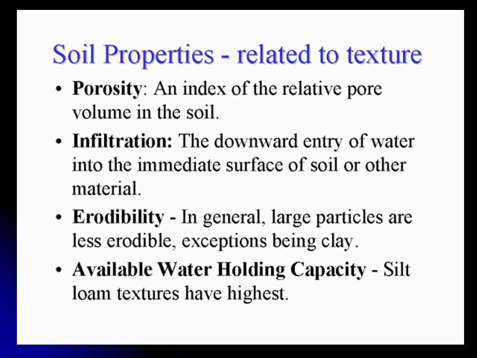
SOIL PHYSICAL PROPERTIES
Color Texture Structure Bulk Density

39
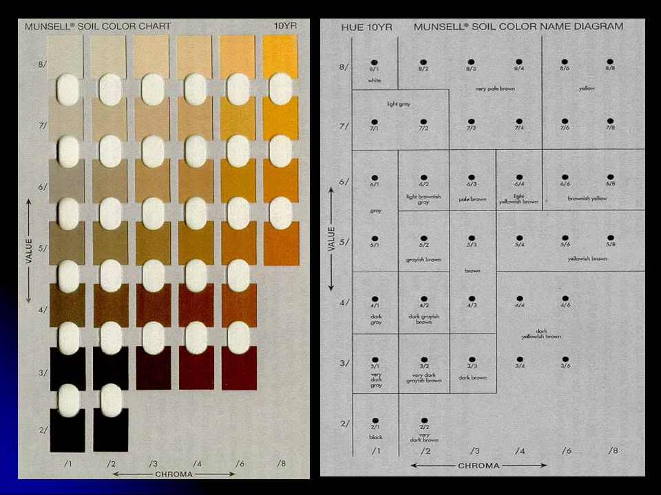
Soil Color Munsell color system - A color designation system that specifies three variables of color. hue (a specific color), indicating a soils relation to red, yellow, green, blue, or purple. Most soils are in the red and yellow hues. On the Munsell Chart--Within each color range (R, YR, Y) the color becomes more yellow and less red as the numbers increase. value (lightness and darkness). On a neutral gray scale, value extends from pure black to pure white; one of the three variables of color. On the Munsell Chart--value, found on the vertical axis, extends from 0 for absolute black to 10 for absolute white.
, indicating a soils relation to red, yellow, green, blue, or purple. Most soils are in the red and yellow hues. On the Munsell Chart--Within each color range (R, YR, Y) the color becomes more yellow and less red as the numbers increase. value (lightness and darkness). On a neutral gray scale, value extends from pure black to pure white; one of the three variables of color. On the Munsell Chart--value, found on the vertical axis, extends from 0 for absolute black to 10 for absolute white.")
40
Soil Color chroma (color intensity) - directly related to the dominance of the determining wavelength of the light and inversely related to grayness; On the Munsell Chart-- chroma, found on the horizontal axis, extending from neutral grays. The order for writing a Munsell notation is hue, value, and chroma with a space between the hue letter and the two numbers. A "/" appears between value and chroma. Example: 10YR 5/6
 - directly related to the dominance of the determining wavelength of the light and inversely related to grayness; On the Munsell Chart-- chroma, found on the horizontal axis, extending from neutral grays. The order for writing a Munsell notation is hue, value, and chroma with a space between the hue letter and the two numbers. A / appears between value and chroma. Example: 10YR 5/6.")
41
K(SixAl4-x)(Al,Fe,Mg)O10(OH)2 5Y 5/1 dark gray iron sulfide FeS
Mineral Formula Size Munsell Color goethite FeOOH (1-2 m m) 10YR 8/6 yellow (~0.2 m m) 7.5YR 5/6 strong brown hematite Fe2O3 (~0.4 m m) 5R 3/6 red (~0.1 m m) 10R 4/8 lepidocrocite (~0.5 m m) 5YR 6/8 reddish-yellow 2.5YR 4/6 ferrihydrite Fe (OH)3 2.5YR 3/6 dark red glauconite K(SixAl4-x)(Al,Fe,Mg)O10(OH)2 5Y 5/1 dark gray iron sulfide FeS 10YR 2/1 black pyrite FeS2 black (metallic) jarosite K Fe3 (OH)6 (SO4)2 5Y 6/4 pale yellow todorokite MnO4 humus calcite CaCO3 10YR 8/2 white dolomite CaMg (CO3)2 gypsum CaSO4× 2H2O 10YR 8/3 very pale brown quartz SiO2 10YR 6/1 light gray Properties of Minerals
 10YR 8/6. yellow. (~0.2 m m) 7.5YR 5/6. strong brown. hematite. Fe2O3. (~0.4 m m) 5R 3/6. red. (~0.1 m m) 10R 4/8. lepidocrocite. (~0.5 m m) 5YR 6/8. reddish-yellow. 2.5YR 4/6. ferrihydrite. Fe (OH)3. 2.5YR 3/6. dark red. glauconite. K(SixAl4-x)(Al,Fe,Mg)O10(OH)2. 5Y 5/1. dark gray. iron sulfide. FeS. 10YR 2/1. black. pyrite. FeS2. black (metallic) jarosite. K Fe3 (OH)6 (SO4)2. 5Y 6/4. pale yellow. todorokite. MnO4. humus. calcite. CaCO3. 10YR 8/2. white. dolomite. CaMg (CO3)2. gypsum. CaSO4× 2H2O. 10YR 8/3. very pale brown. quartz. SiO2. 10YR 6/1. light gray. Properties of Minerals.")
44
Tale 15.1

51
Soil structure Building and maintaining a good structure depends on
The influence of organic matter The shrink swell processes associated with wetting and drying or freezing and thawing The action of plant roots and soil microorganisms The modifying effects of adsorbed cations

52
Granular: Resembles cookie crumbs and is usually less than 0
Granular: Resembles cookie crumbs and is usually less than 0.5 cm in diameter. Commonly found in surface horizons where roots have been growing. Blocky: Irregular blocks that are usually cm in diameter Prismatic: Vertical columns of soil that might be a number of cm long. Usually found in lower horizons. Columnar: Vertical columns of soil that have a salt "cap" at the top. Found in soils of arid climates.

53
Platy: Thin, flat plates of soil that lie horizontally.
Usually found in compacted soil. Massive: Soil has no visible structure, is hard to break apart and appears in very large clods. Single Grained: Soil is broken into individual particles that do not stick together. Always accompanies a loose consistence. Commonly found in sandy soils

54
GRANULAR Blocky Columnar Prismatic Platy

55
Single grained Massive

56
Bulk Density Bulk Density is the weight of a given volume of soil which includes the pore spaces. It can be easily measured by gently pressing a small cylinder into the soil, removing the core and weighing after\drying to remove the water contained in the pore space. An average value would be 1.3 g per cm3. Coarse textured soils will usually have a higher bulk density because they have less pore space than fine textured soils.

57
Bulk Density Bulk density is an important property of soils since it affects how easily plant roots can penetrate the soil when they propagate. Real Density is the weight of a given volume of the soil solids only. It would be equivalent to the average density of the soil minerals and the organic matter. An average value is 2.65 g per cm3.

58
Bulk Density Porosity or pore space of soils is calculated simply from the Bulk Density (Db) and Real or Particle density (Dp) Porosity = 1 - Db/Dp An example of a soil that has a Real Density of 2.65 g per cm3 and a Bulk Density of 1.3 g per cm3 and converting to percentages. % Porosity = (1.3/2.65) x 100 = 50%
 x 100 = 50%")
59
Ion Exchange in Soils As a result of negative charges developed by soil colloids ions are absorbed on the surfaces of these colloids in soils. The ions absorbed are include Ca2+, Mg2+, K+, Al3+, and Na+. In humid regions Ca2+, Al3+ and H+ are by far the most numerous cations absorbed. Al3+ and H+ tend to dominate in humid regions. In semi-arid regions Ca2+, Mg2+, K+, and Na+ tend to dominate.

60
Sources Negative Charge:
The main source of charge on clay minerals is isomorphous substitution which confers permanent charge on the surface of most layer silicates. Ionization of hydroxyl groups on the surface of other soil colloids and organic matter can result in what is describes as pH dependent charges-mainly due to the dependent on the pH of the soil environment.

61
Sources Negative Charge:
Unlike permanent charges developed by isomorphous substitution, pH-dependent charges are variable and increase with increasing pH. Presence of surface and broken - edge -OH groups gives the kaolinite clay particles their electronegativity and their capacity to absorb cations. In most soils there is a combination of constant and variable charge

62
Cation Exchange Displacement of one cation by another results in the process called cation exchange. For example: H+ produced by organic acid. Under high rainfall conditions, Ca leached. Under low rainfall conditions, Ca and other soils are not easily leached.

63
Factors Affecting Cation Exchange
The charge of the ion. Generally ions with higher valency will exchange for those of lower valency. For example; Al3+ > Ca2+ > Mg2+ > K+ = NH4+ >Na+ For ions of same charge, the cation with the smallest hydrated radius is strongly absorbed because it moves close to the site of charge.

64
Factors Affecting Cation Exchange
For examples K with a hydrated radius of nm, will exchange for Na, hydration radius of nm, on the exchange sites. The rate of ion exchange in soils is affected by the type and quantity of organic and inorganic colloids. Clay minerals with 1:1 lattice tend to have more rapid rate of exchange than 2:1 clays which have both internal and external exchange sites.

65
Cation Exchange Capacity of Soil
Cation-exchange capacity (CEC) is defined as the quantity of cations that are reversibly adsorbed per unit mass of the (dry) matter. Moles of positive charge / dry weight of soil For clay CEC = centimoles (cmol)/kg For peat CEC ~400 cmol/kg
 is defined as the quantity of cations that are reversibly adsorbed per unit mass of the (dry) matter. Moles of positive charge / dry weight of soil. For clay CEC = centimoles (cmol)/kg. For peat CEC ~400 cmol/kg.")
66
Cation Exchange Capacity
The cation exchange capacity of soils (CEC) is defined as the sum of positive (+) charges of the adsorbed cations that a soil can adsorb at a specific pH. Cation Exchange Capacity (CEC) is expressed as centimoles of positive charge per kilogram (cmol kg-1) , of oven dry soil.
 is defined as the sum of positive (+) charges of the adsorbed cations that a soil can adsorb at a specific pH. Cation Exchange Capacity (CEC) is expressed as centimoles of positive charge per kilogram (cmol kg-1) , of oven dry soil.")
67
Cation Exchange Capacity
Earlier unit was meq per 100 g soils. Equivalent weight: Quantity that is chemically equal to 1 gram of H. Number of H in equivalent weight is 6.02x10²³ or Avogadro's number. Milli equivalent is equal to gr.mol of H. Total cation exchange capacity of the soil is the total number of exchange sites of both the organic and mineral colloids.

68
Cation Exchange Capacities of Clay Minerals
Colloid Type CEC (cmol Kg-1) Kaolinite 2-15 Montmorillonite 80-150 Chlorite 10-40 Vermiculite (Trioctahedral) Vermiculite (Dioctahedral) 10-150 Allophane 3-250 Gibbsite 4 Goethite
 Kaolinite Montmorillonite Chlorite Vermiculite (Trioctahedral) Vermiculite (Dioctahedral) Allophane Gibbsite. 4. Goethite.")
69
Cation Exchange Capacities of Soil The CEC of a given soil is determined by the relative amounts of different colloids in that soil and by the CEC of each of these colloids. Sandy soils generally have lower CEC than clay soil because coarse textured soils have lower amounts of both clays and organic matter. Soils Order CECs (cmol kg-1) pH Ultisols 3.5 5.6 Alfisols 9.0 6.0 Spodosols 9.3 4.93 Mollisols 18.7 6.51 Vertisols 35.6 6.72 Aridisols 15.2 7.26 Inceptisols 14.6 6.08 Entisols 11.6 7.32 Histosols 128.0 5.50
 pH. Ultisols Alfisols Spodosols Mollisols Vertisols Aridisols Inceptisols Entisols Histosols")
70
CATION EXCHANGE CAPACITY OF SOIL

71
Importance of Cation Exchange
Cation exchange at negative sites is major retention mechanism for heavy metals, e.g. Cd, Pb and Zn. Measurement of CEC The CEC of soil is usually measured by saturating the soil with an index cation such as Na+, removal of the excess salts of the index cation with a dilute solution , and then displacing the Na+ with another cation . The amount of Na+ displaced is then measured and the CEC is calculated.

72
Anion Exchange and Adsorption
Anion exchange arise from the protonation of hydroxyl groups on the edges of silicate clays and on the surfaces of metal oxide clays. Anion exchange is inversely related with pH is greatest in soils dominated by the sesquioxides (Al2O3 etc.). The anions Cl-, NO3-, and SeO42- and to some extent HS- ands SO42-, HCO3-, and CO3- adsorb mainly by ion exchange. Borate, phosphate and carboxylate adsorb principally by specific adsorption mechanisms.
. The anions Cl-, NO3-, and SeO42- and to some extent HS- ands SO42-, HCO3-, and CO3- adsorb mainly by ion exchange. Borate, phosphate and carboxylate adsorb principally by specific adsorption mechanisms.")
73
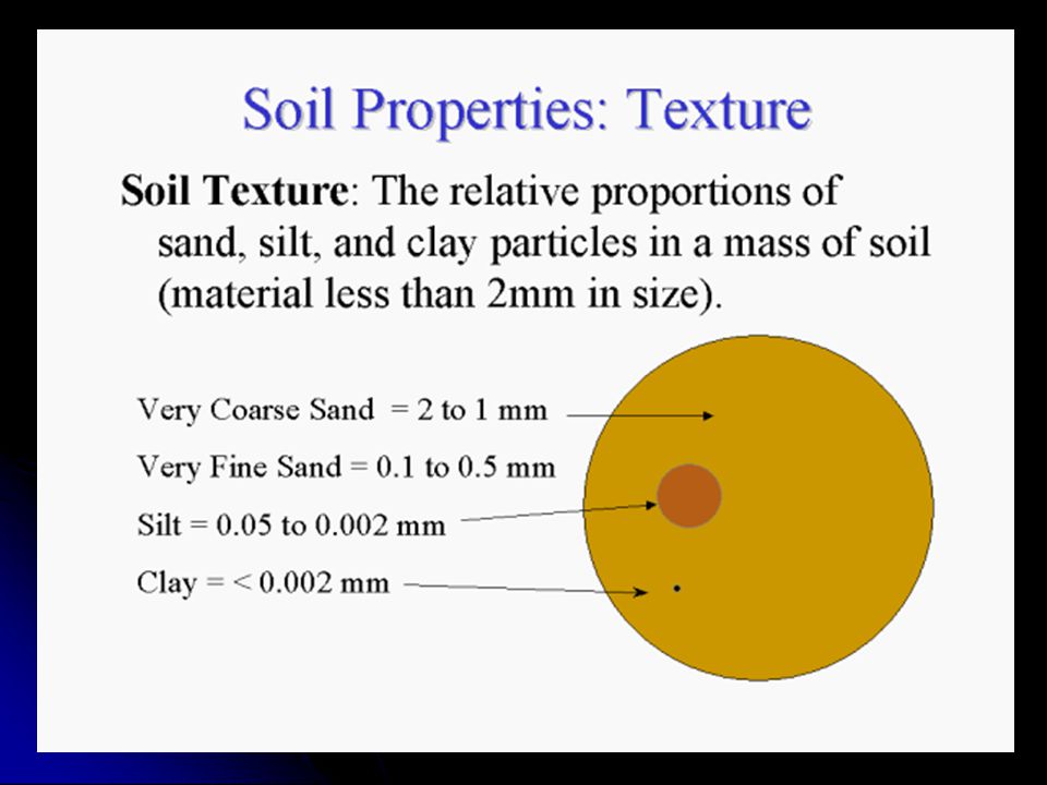
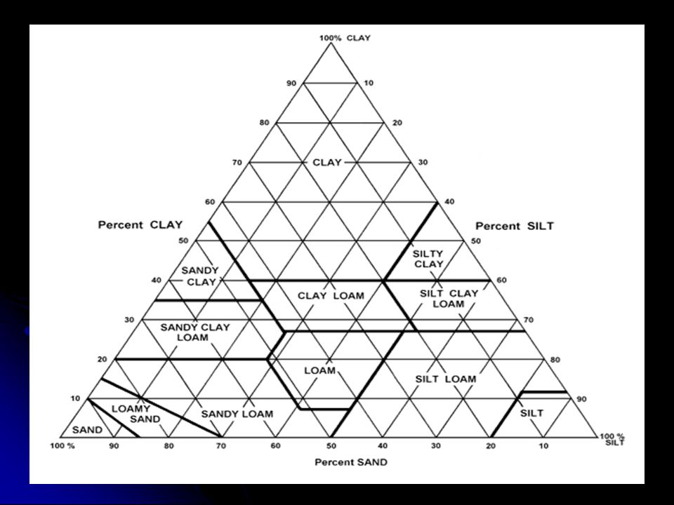
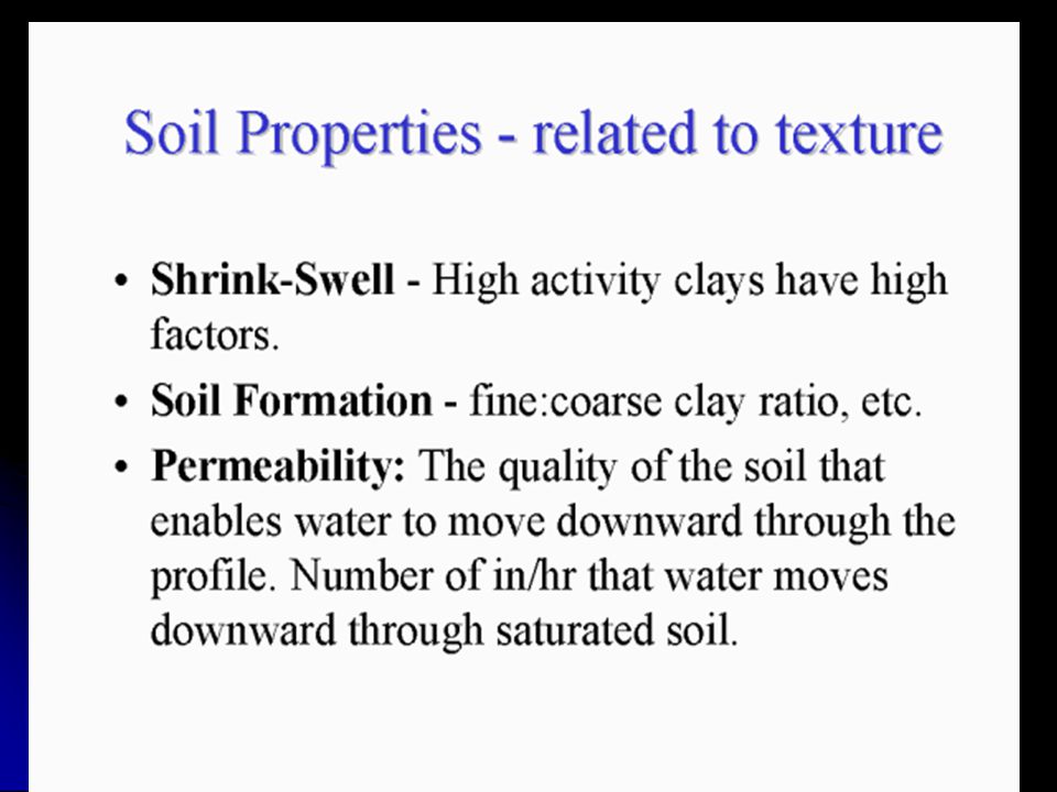
Soil Texture, Bulk Density and Porosity
POROSITY OF SOIL Texture, structure and organic matter are all important in determining the overall soil porosity. Coarse textured sandy soils have larger pores but much less pore space than finer textured clay soils. Soil Texture, Bulk Density and Porosity Texture Bulk Density % Porosity Sand 1.6 40 Loam 1.2 55 Clay 1.05 60

75
Engineering Properties of Soils
Erodibility: The ease with which soil is removed by wind or water Hydraulic conductivity: The ease of soil to allow water to move through Corrosion potential: Chemical interaction with metals

76
Engineering Properties of Soils (2)
Shrink-swell potential: Soil’s tendency to gain or lose water Expansive soils: Causing significant environmental problems Changes in moisture content Topography and drainage also significant

Benzer bir sunumlar


 ZONAL (YERLİ TOPRAKLARI)>")


